I have been doing quite a bit of work with businesses and government organisations on how to use Google Maps in real time and in particular the predictive Journey times and Estimated time of Arrival (ETA) functionality available through the Google Maps APIs.
One question that always comes up is how accurate the journey times are. So, I decided to put Google Maps to the test to find out just how reliable it is.
Testing the accuracy of Google Maps journey times
Google does not provide much documentation on the actual accuracy of their journey times, so it often comes down to the potential user to test this for themselves. Having used Google Maps for my own in-car navigation for a few years, I believe the predicted journey times are indeed very accurate. I would quite often let the person at the other end of my journey know my ETA and — bingo — arrive at that exact time. However, I had not validated the accuracy of the journey times. This is exactly what I have been doing over the last couple of months.
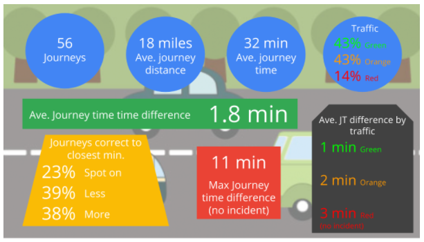
Over the past two months, I have noted the predicted journey time at the start of any car trip and measured this against the actual time. Having completed the analysis, I can confirm that, as expected, the Google Maps journey times are very accurate. Below is a summary of my findings.
Google Maps journey time analysis and findings
To undertake the analysis, I would enter my route into Google Maps, note down the predicted journey and arrival times and compare these to the actual times. I tried my best to stick to good driving behaviour, speed limit etc. to make sure the results were as representative as possible.
I conducted 56 individual trips with an average distance of 18 miles and journey time of 32 minutes. The trips were mainly from my house in Hampshire to locations in the South of England. I spent an average amount of each journey on motorways, A and B roads, with the odd country lane thrown in for good measure. I also recorded the traffic conditions based on the Google Maps navigation app and if the whole route equaled green, orange or red traffic. The majority of my trips were in green or orange, but I did have some with red traffic for comparison.
Considering the number of journeys I undertook and their average time and distance, I think an average of 1.8 min out of predicted journey time is a very good result. This gives me a lot of confidence about the accuracy of Google Maps journey times. It also gives me a lot of confidence that the technology we are offering to our customers is the best and most accurate there is.
One thing to note is that the journey time accuracy went down based on the amount of traffic on the route and the distance travelled. This is expected as those two variables make predicting journey times much harder. However the accuracy does not fall by a significant amount and my confidence in Google’s journey accuracy stays high even when undertaking long trips in traffic.
One further thing to note is I excluded from the results any trip that had an unpredictable incident such as a car crash, although there was only one such incident over my trips.
How does Google Maps work out journey times?
Google calculates journey time by measuring the distances between your two chosen points, and applying any speed limits that are in place on the route to provide a perceived average speed for the journey. This is then used to compute the forecast arrival time at the destination.
Crucially, however, Google Maps also layers over additional live, real-time data to ensure that these trip times are as accurate as possible. Data is sent anonymously to Google from Apple of Android smartphones that have Google Maps open, or from any Android device that shares location information. This data is then used to provide real-time updates on traffic congestion and incidents, which is then taken into account alongside the distance and typical journey time to provide a more reliable and realistic estimate.
The evolution of Google Maps journey time predictions
Google Maps journey time predictions have evolved to the point where they can now give highly accurate real and predictive journey times, even over long distances and in rush hour traffic conditions. These journey times have a wide range of uses, not only in the consumer world to help people navigate and understand when they will arrive at their destination but also in business and government to help improve customer service and plan new infrastructure.
I believe the journey times provided by Google Maps are the most accurate available in the UK and Europe, and most probably in the world. This information can help businesses and government services improve the services they provide and do so in a much more cost effective manner. I will be exploring some of these use cases and how Google predicts its journey times in subsequent posts.
Working with a Google Maps Premier Partner
A Google Cloud Partner like Ancoris can help you apply the power of Google Maps to solve current business challenges and develop new digital models using location-based services.
We’re not only a Google Maps Premier Partner but have achieved Google’s Location-Based Services Partner Specialisation. This means we’ve demonstrated both technical proficiency and proven success in building and managing applications using the best of Google Maps Platform and Google Cloud Platform in both web and mobile environments.
If you’d like to find out more about how we can help you, why not take a look at some of our customer success stories or talk to the experts in our Google Maps team.
Article updated June 2022
First published February 2018

